Thank you for supporting this site ❤️
Make a donation
Make a donation
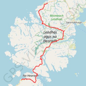
Hebridean Way
- Distance: 102.1 Km
- Elevation gain: 1,332 m
- Maximum elevation: 200 m
- Elevation loss: 1,309 m
- Minimum elevation: 0 m
- Moving time: 7 h 6 m
- Moving speed: 14.4 Km/h
- Maximum speed: 56.3 Km/h
- Total time: 9 h 30 m
- Global speed: 10.7 Km/h
Interactive trail map
Thank you for supporting this site ❤️
Make a donation
Make a donation
Trail profile
- Distance: 102.1 Km
- Elevation gain: 1,332 m
- Maximum elevation: 200 m
- Elevation loss: 1,309 m
- Minimum elevation: 0 m
- Moving time: 7 h 6 m
- Moving speed: 14.4 Km/h
- Maximum speed: 56.3 Km/h
- Total time: 9 h 30 m
- Global speed: 10.7 Km/h
Thank you for supporting this site ❤️
Make a donation
Make a donation
About this trail
Name: Hebridean Way trail, distance, elevation, map, profile, GPS track
Coordinates: 57.84621 -6.97980 58.32104 -6.49592
Thank you for supporting this site ❤️
Make a donation
Make a donation