
El toro church to summit and back
From West Hills Community Church in Morgan Hill, the route leaves the neighborhood edge and joins the Open Space Authority Trail toward El Toro Open Space Preserve.
It climbs through open grassland, oak woodland, and hillside switchbacks toward the prominent El Toro summit, a local landmark above the Santa Clara Valley.
After the summit viewpoint, the hike returns by the same hillside approach, with broad views over Morgan Hill and the surrounding foothills.
#Hiking #Nature #Forest #Mountain
- Distance: 4.1 Km
- Elevation gain: 298 m
- Maximum elevation: 417 m
- Elevation loss: 302 m
- Minimum elevation: 133 m
- Moving time: 46 m 37 s
- Moving speed: 5.2 Km/h
- Maximum speed: 25.4 Km/h
- Total time: 49 m 35 s
- Global speed: 4.9 Km/h
Interactive trail map
Trail profile
- Distance: 4.1 Km
- Elevation gain: 298 m
- Maximum elevation: 417 m
- Elevation loss: 302 m
- Minimum elevation: 133 m
- Moving time: 46 m 37 s
- Moving speed: 5.2 Km/h
- Maximum speed: 25.4 Km/h
- Total time: 49 m 35 s
- Global speed: 4.9 Km/h
About this trail
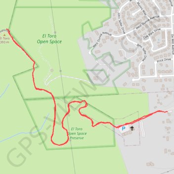
Name: El toro church to summit and back trail, distance, elevation, map, profile, GPS track
Coordinates: 37.11456 -121.67317 37.12085 -121.66223