
Tracked with OSMTracker for Android™
.
- Distance: 18.7 Km
- Elevation gain: 84 m
- Maximum elevation: 74 m
- Elevation loss: 143 m
- Minimum elevation: 12 m
- Moving time: 2 h 46 m
- Moving speed: 6.7 Km/h
- Maximum speed: 53.7 Km/h
- Total time: 12 h 42 m
- Global speed: 1.5 Km/h
Interactive trail map
Trail profile
- Distance: 18.7 Km
- Elevation gain: 84 m
- Maximum elevation: 74 m
- Elevation loss: 143 m
- Minimum elevation: 12 m
- Moving time: 2 h 46 m
- Moving speed: 6.7 Km/h
- Maximum speed: 53.7 Km/h
- Total time: 12 h 42 m
- Global speed: 1.5 Km/h
About this trail
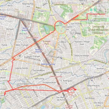
Name: Tracked with OSMTracker for Android™ trail, distance, elevation, map, profile, GPS track
Coordinates: 14.61974 121.02215 14.65772 121.07082
Topography: Quezon City topographic map, elevation, terrain
Other hiking, mountain biking, running and outdoor activity trails
Click on a trail to view its statistics, map and profile.
Tracked with OSMTracker for Android™
.
Distance: 8.4 Km • Elevation gain: 48 m • Maximum elevation: 53 m